

Surface Oil Trajectories during a Katrina-like Storm
By Steve Morey and Dmitry Dukhovskoy, Center for Ocean-Atmospheric Prediction Studies.
Introduction:
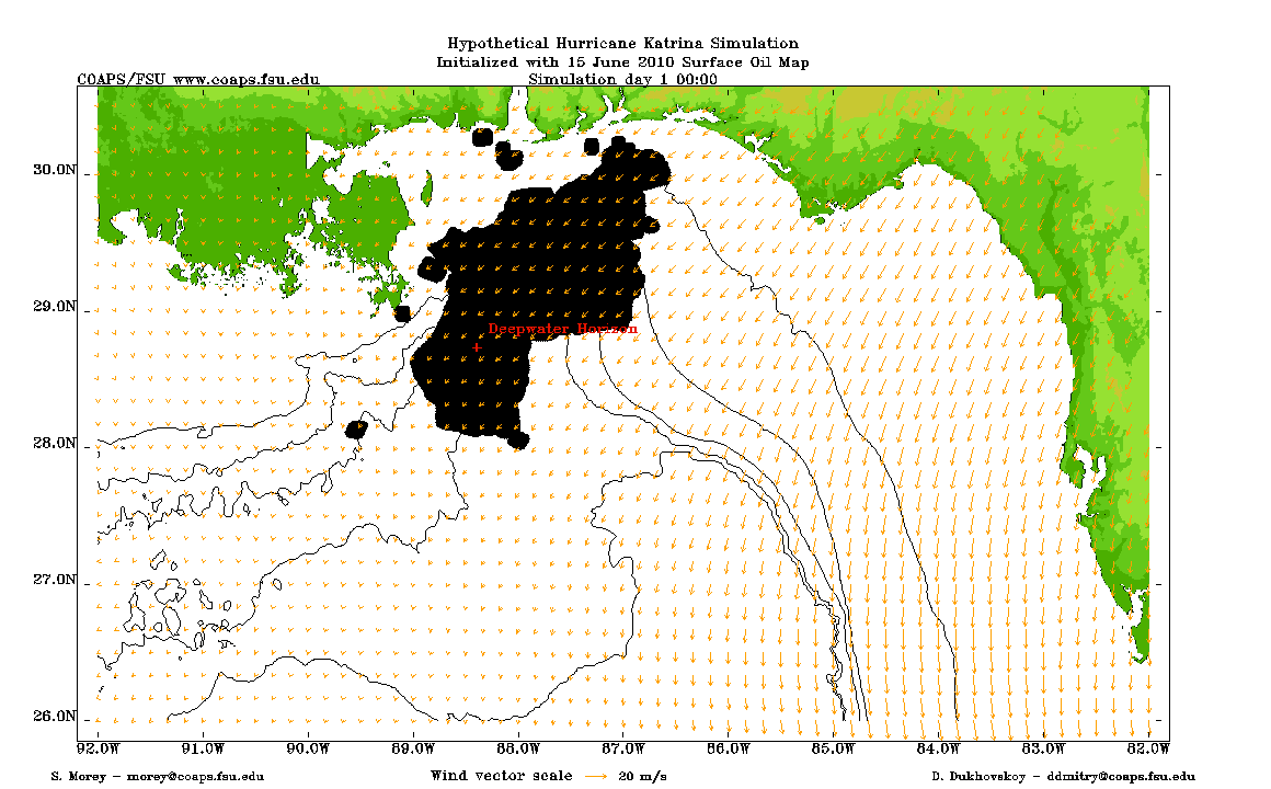
A pressing question as we enter hurricane season, particularly with the forecast for increased tropical activity, is what might happen to the oil in the Gulf during a hurricane and its associated storm surge. To look at this problem, we have run simulations for a hypothetical case of a Katrina-like storm occurring with the oil in its present location. Results from these experiments show us a number of things. First, it is expected that oil can be transported far onshore with the storm surge. Second, for a storm approaching the northern Gulf coast, winds and surface transport will initially be from east to west before turning onshore (east of the hurricane eye) as the storm makes landfall. This means that the surface oil should dominantly affect locations in the western part of the area. For the Katrina storm, we predict significant oil inundation of southeastern Louisiana and likely the Mississippi and Alabama coastlines with little Florida impact. Finally, it is not well-known how the oil will behave under strong hurricane winds. Modifications in simple methods of parameterizing the effects of wind on the surface oil transport yield very different results. Increased wave-induced mixing may also enhance emulsification of the oil. Further research is needed to better understand these issues and more accurately predict the fate of the oil during a hurricane.
Surface Oil Trajectories with FVCOM Currents
Click on image to view animation.

Surface Oil Trajectories with FVCOM Currents and Wind Drift
Click on image to view animation.
Technical Details:
A model of the Gulf of Mexico was constructed using the unstructured grid Finite Volume Coastal Ocean Model (FVCOM). The model has no currents except for the locally wind-generated currents. It is barotropic (constant density) but is configured as a 3-D model (8 sigma levels) to allow for vertical shear, particularly important for shallow regions. The model is forced by wind fields derived by blending the NOAA Hurricane Research Division H*Wind fields (Powell et al., 1998) with the NCEP Reanalysis II winds to complete the far field.
The surface oil transport algorithm simply treats oil as a large number of passive Lagrangian drifters, with their trajectories computed using a forth-order Runge-Kutta scheme. The initial oil location is prescribed using the NOAA nearshore map for June 15. Two scenarios are run: one in which transport is only by the FVCOM currents, and second in which the transport velocity is the vector sum of the surface current plus the wind drift computed as 3.5% of the wind speed at a variable deflection angle prescribed by Samuels et al. (1982).
References:
Powell, M.D., S.H. Houston, L.R. Amat, and N. Morisseau-Leroy (1998), The HRD real-time hurricane wind analysis system, J. Wind Engineer. and Indust. Aerodyn., 77, 53-64.
Samuels, W.B., N.E. Huang, and D.E. Amsiuiz (1982), An oilspill trajectory analysis model with a variable wind deflection angle, Ocean Engineering, 9, 347-360.